GREENLAND ICE SHEET HYDROLOGY
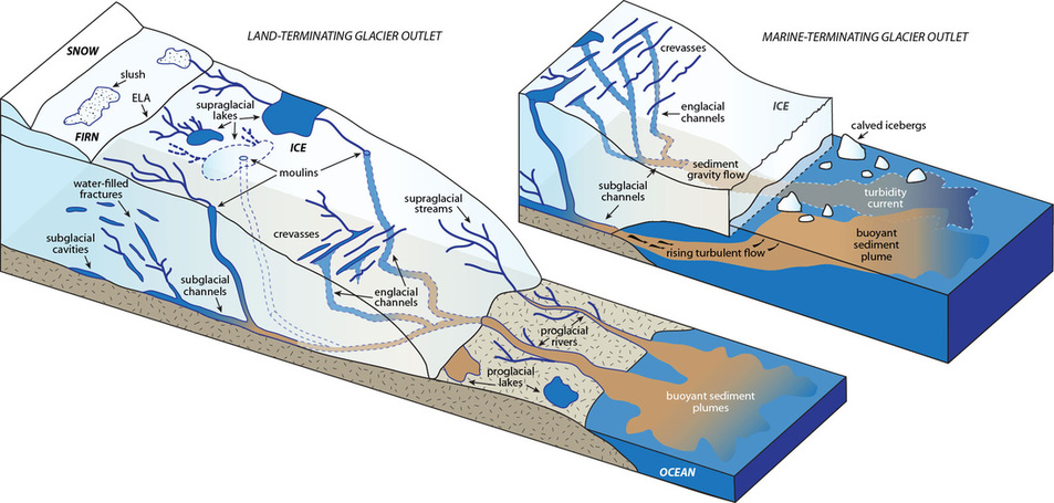
Understanding the Greenland ice sheet is essential for evaluating future contributions to global sea level rise in a warming climate. Recently observed increases in temperature and melt extent over the ice sheet have prompted numerous remote sensing, modeling, and field studies gauging the response of the ice sheet and outlet glaciers to increasing meltwater input. The Greenland ice sheet hydrologic system is characterized by supraglacial streams and lakes that drain through moulins, providing an influx of meltwater into englacial and subglacial environments that increases basal sliding speeds of outlet glaciers in the short-term. However, englacial and subglacial drainage systems may adjust to efficiently drain increased meltwater without significant changes to ice dynamics over seasonal and annual scales. Both proglacial rivers originating from land-terminating glaciers and subglacial conduits under marine-terminating glaciers represent direct meltwater outputs in the form of fjord sediment plumes, visible in remotely sensed imagery.
Related publications:
- Chu, V.W. (2014). Greenland Ice Sheet hydrology: a review. Progress in Physical Geography, 38(1): 19-54, doi:10.1177/0309133313507075.
- Rennermalm, A.K., Moustafa, S.E., Mioduszewski, J., Chu, V.W., Forster, R.R., Hagedorn, B., Harper, J.T., Mote, T.L., Robinson, D.A., Shuman, C.A., Smith, L.C., and M. Tedesco (2013). Understanding Greenland ice sheet hydrology using an integrated multi-scale approach. Environmental Research Letters, 8(1):1-14, doi:10.1088/1748-9326/8/1/015017.
Greenland Ice Sheet supraglacial rivers
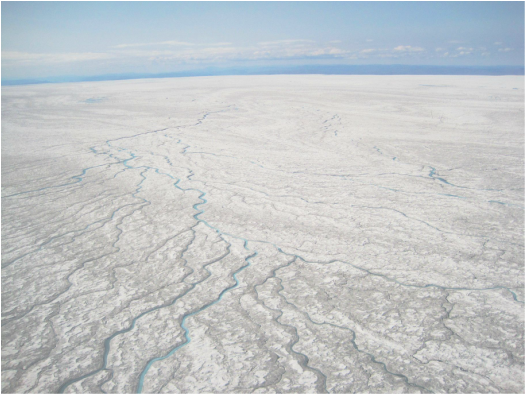
Satellite images show the western Greenland ablation zone littered with supraglacial melt ponds and dense networks of streams developing throughout the melt season. Stream formation depends on downcutting by surface channels exceeding surface ablation rates, with channel incision driven mostly by thermal erosion. Almost all supraglacial stream networks terminate in moulins, carrying melwater into the ice sheet.
While there are numerous field studies of supraglacial streams on Arctic glaciers, very few exist for the GrIS. An extensive field campaign on the ice sheet in summer 2012 provide the basis for empirical retrieval of discharge. My current work focuses on mapping supraglacial river discharge over western Greenland using WorldView-2 imagery and field-derived algorithms. |
Related publications:
- Smith, L.C., Chu, V.W., Yang, K., Gleason, C.J., Pitcher, L.H., Rennermalm, A.K., Legleiter, C.J., Behar, A.E., Overstreet, B.T., Moustafa, S.E., Tedesco, M., Forster, R.R., LeWinter, A.L., Finnegan, D.C., Sheng, Y., and J. Balog (2015). Efficient meltwater drainage through supraglacial streams and rivers on the southwest Greenland ice sheet. Proceedings of the National Academy of Sciences, doi:10.1073/pnas.1413024112.
- Chu, V.W., Smith, L.C., Yang, K., Leglieter, C.J., Gleason, C.J., and A.K. Rennermalm (In revision). Adaptation of Manning's equation for remote estimation of supraglacial river discharge using GIS modeling and WorldView-2 satellite imagery. GIScience & Remote Sensing.
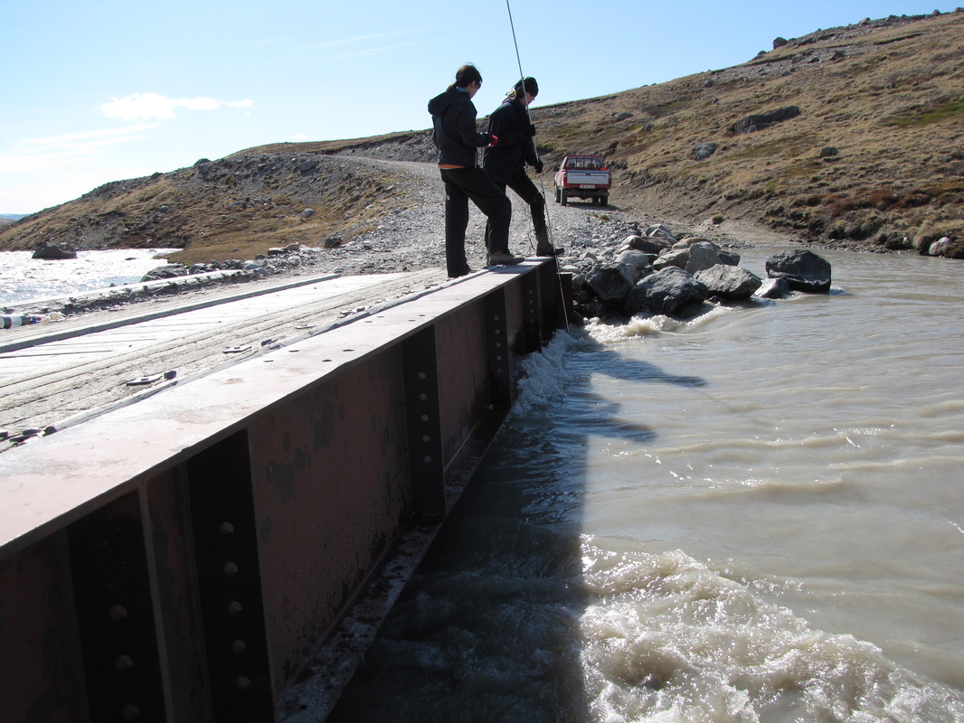
Greenland proglacial riversThe Greenland proglacial hydrologic environment consists of rivers and lakes draining the ice margin as well as non-glacially influenced river and lakes formed from snowmelt and precipitation. Monitoring discharge from rivers draining the ice sheet allows for not only assessing actual meltwater losses but also for inferring en-/subglacial drainage network organization and meltwater retention. However, such observations are very rare due to the difficulties in logistical setup in such remote areas.
The UCLA/Rutgers research group has maintained discharge stations in since 2008 in the Watson River basin near Kangerlussuaq, southwest Greenland. |
Related publications:
- Rennermalm, A.K., Smith, L.C., Chu, V.W., Box, J.E., Forster, R.R., van den Broeke, M., van As, D., and S. E. Moustafa (2013). Evidence of meltwater retention within the Greenland ice sheet. The Cryosphere, 7(5):1433–1445, doi:10.5194/tc-7-1433-2013.
- Rennermalm, A.K., Smith, L.C., Chu, V.W., Forster, R.R., Box, J.E., and B. Hagedorn (2012). Proglacial river stage, discharge, and temperature datasets from the Akuliarusiarsuup Kuua River northern tributary, Southwest Greenland, 2008–2011. Earth System Science Data, 4: 1-12, doi:10.5194/essd-4-1-2012.
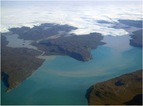
Greenland fjord sediment plumesSediment-rich meltwater entering fjords from both marine-terminating outlet glaciers and rivers from land-terminating glaciers can become buoyant on the water surface, creating a turbid sediment plume visible in satellite imagery. The presence of sediment plumes in outlet glacier fjords signals freshwater release from the ice sheet to the ocean, with plumes showing lower salinity and higher suspended sediment concentration (SSC) than surrounding marine water.
The image on the right shows a map of sediment plumes around Greenland, representing a spatial and temporal climatology of metlwater export. High sediment concentration is associated with high ice sheet surface melting and/or a high proportion of land-terminating glaciers |
Related publications:
- Chu, V.W., Smith, L.C., Rennermalm, A.K., Forster, R.R., and J.E. Box (2012). Hydrologic controls on coastal suspended sediment plumes around the Greenland Ice Sheet. The Cryosphere 6(1):1-19, doi:10.5194/tc-6-1-2012.
- Chu, V.W., Smith, L.C., Rennermalm, A.K., Forster, R.R., Box, J.E., and N. Reeh (2009). Sediment plume response to surface melting and supraglacial lake drainages on the Greenland ice sheet, Journal of Glaciology, 55(104):1072-1082.


